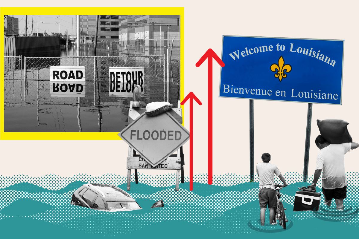
A new map shows how parts of Louisiana could be swallowed up by the sea if ocean levels rise, amid warnings from experts that coastal states are likely to be among those worst-hit by climate change.
The National Oceanic and Atmospheric Administration (NOAA) has created an interactive map showing how the country's coastline could change under various sea level rises. Interested residents can head to the agency's website to play around with the tool that allows users to view a map of the state, and observe how it would be affected by different sea levels.
Beach towns may find themselves underwater within the span of a lifetime, according to some scientists, who predict that sea levels could jump dramatically by the year 2100, altering the shape of American shorelines. The Intergovernmental Panel on Climate Change (IPCC) estimated there is likely to be up to 1.1 meter (3.6 feet) of sea level rise by the year 2100 if global greenhouse gas emissions are not mitigated, but said a sea level increase "of 2 or more meters [almost 6.6 feet] cannot be ruled out."
Sea levels are predicted to rise as ice sheets, particularly around the poles, continue to melt. Antarctica alone contains enough frozen water that it would raise sea levels by an astronomical 190 feet if it were to all melt, according to scientists analyzing the trend.
However, a complete loss of ice sheets could take thousands of years to occur and it is notoriously difficult to predict with any certainty; for example, there could be a sudden collapse that displaces a huge amount of water into the ocean almost instantly as the ice breaks up and melts. And some scientists have argued sea rise calculations may be inaccurate, while others point out the level of the sea has always fluctuated.
In addition, such analysis does not take into account future innovations or legislation to help tackle climate change that could slow or reverse the melting, and nor can it factor in construction projects, such as protective sea defenses, that could potentially be built in years to come.
Nevertheless, NOAA'S interactive map, available on its website, shows how the U.S. looks at present, with current sea heights set at the Mean Higher High Water (MHHW) level, which is the average level of the highest tide each day observed over a 19-year period.
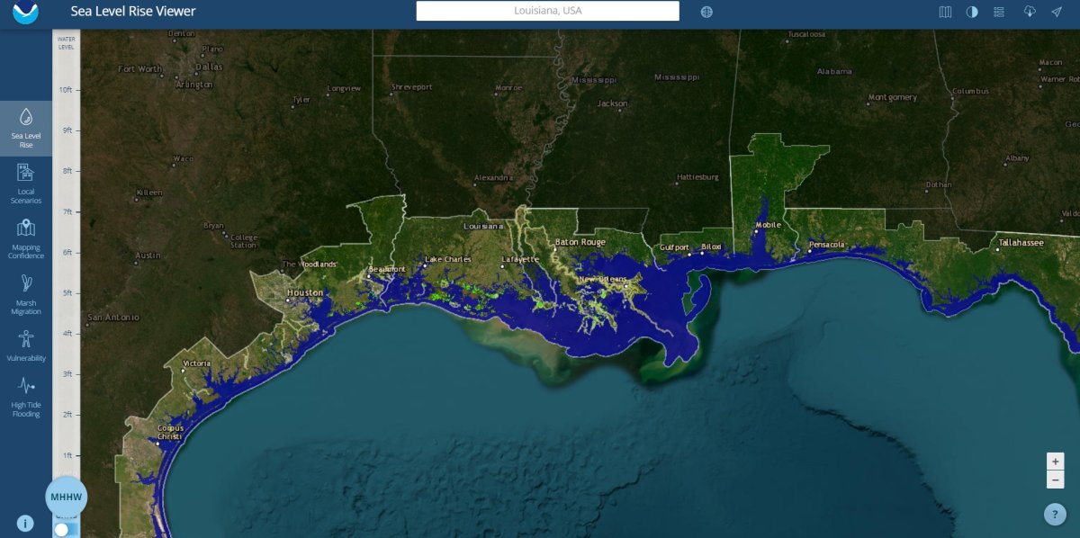
But the map's tools also show how Louisiana would look if sea levels were to change.
For example, the map below shows how the state would fare if sea levels rise by 6 feet. Areas of new ocean are denoted in light blue and show how the coastline would be eroded significantly.
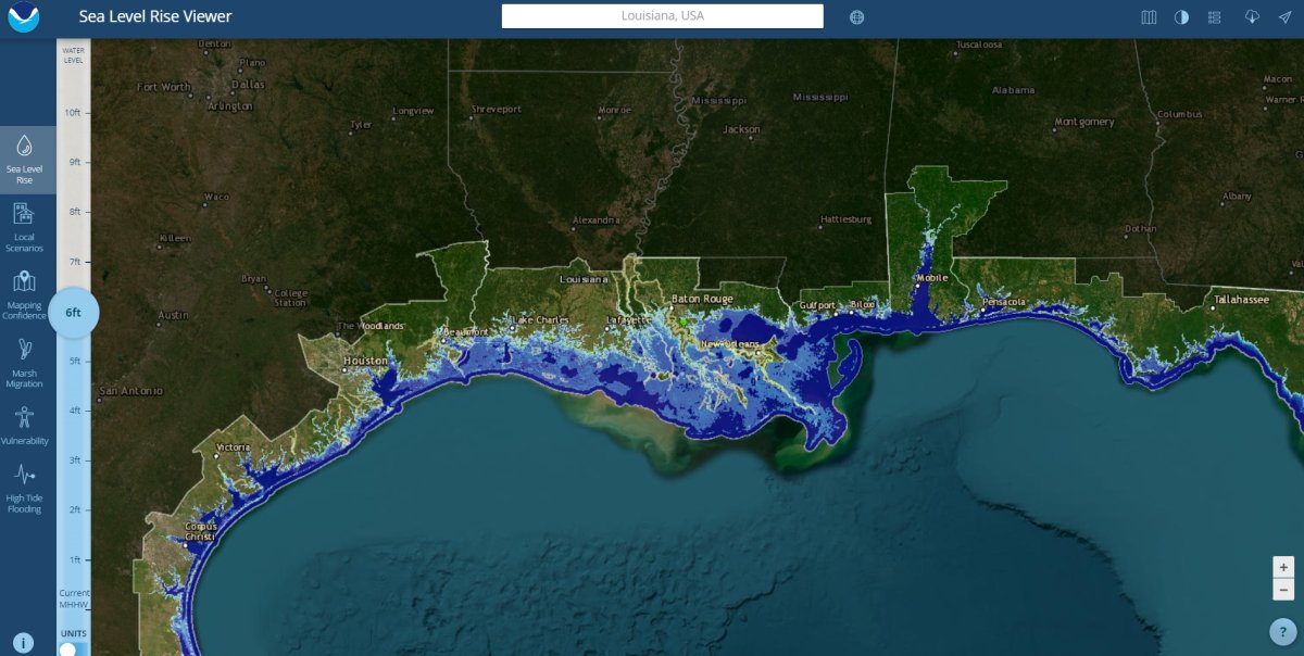
Cameron Parish, home to more than 5,600 people according to the 2020 census and known for the Creole Nature Trail, could be completely submerged if sea levels rise by 6 feet. Areas of higher ground south of Black Lake and near Hackberry could become tiny islands.
And the rising waters could push inland past the northern part of Calcasieu Parish and into Jefferson Davis Parish.
Key cities would not escape unscathed either, according to the NOAA projections. Parts of Lafayette could become waterlogged, while the parish of West Baton Rouge, would be submerged, according to the interactive map.
Area surrounding New Orleans could also be claimed by the sea. Golfers would lose the Belle Terre Country Club, with whole neighborhoods submerged between there and the Riverlands Golf and Country Club.
Louisiana is not the only state that would be affected by such sea level rises, should they occur in future.
A previous analysis by National Geographic in 2013 suggested that parts of New York would vanish, along with the whole of Florida if all the world's ice sheets melted.
Even under less extreme scenarios, portions of Los Angeles and San Diego could disappear.
David Thornalley, a professor of ocean and climate science at University College London, warned that 2100 was only a single lifespan away, telling Newsweek that significant sea rises "would happen if we didn't take steps to reduce our GHG (greenhouse gas) emissions."
NOAA oceanographer William Sweet said in an emailed response: "NOAA's Sea Level Rise Viewer is a versatile mapping platform that provides insights on what lies in harm's way—either from on-going sea level rise or flooding from full-moon tides to hurricane storm surges.
"Due to decades of sea level rise, high tides are drowning wetlands and routinely flooding U.S. coastal communities, disrupting commutes and commerce and requiring extensive upgrades to public works like storm- and waste-water systems."
Uncommon Knowledge
Newsweek is committed to challenging conventional wisdom and finding connections in the search for common ground.
Newsweek is committed to challenging conventional wisdom and finding connections in the search for common ground.
About the writer
Get in touch with Chloe Mayer by emailing c.mayer@newsweek.com
To read how Newsweek uses AI as a newsroom tool, Click here.