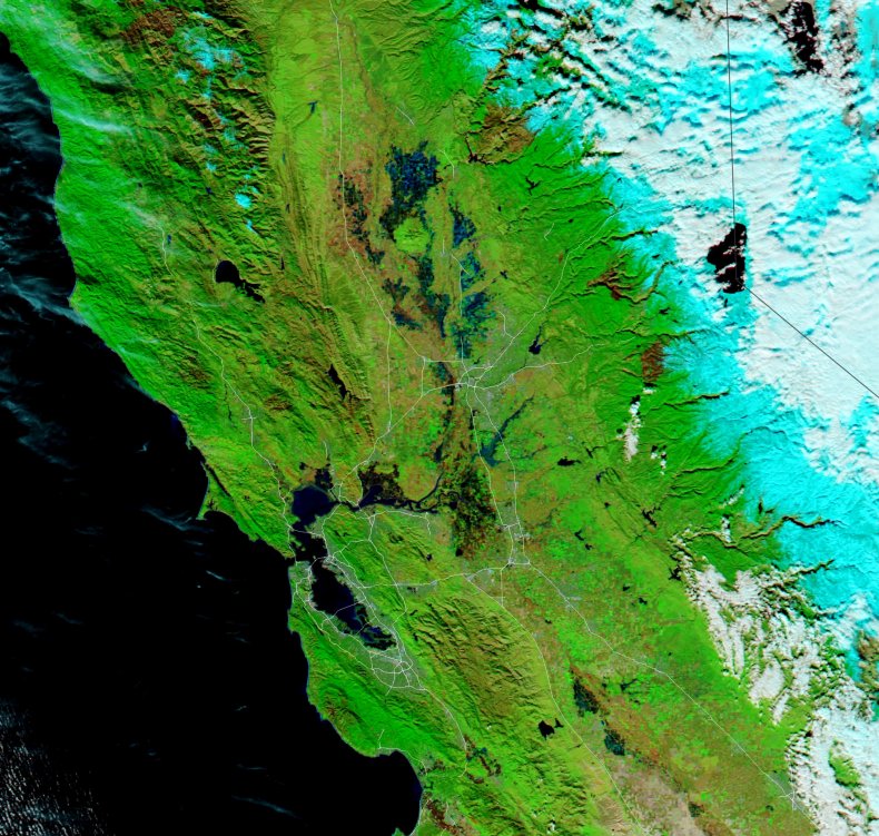
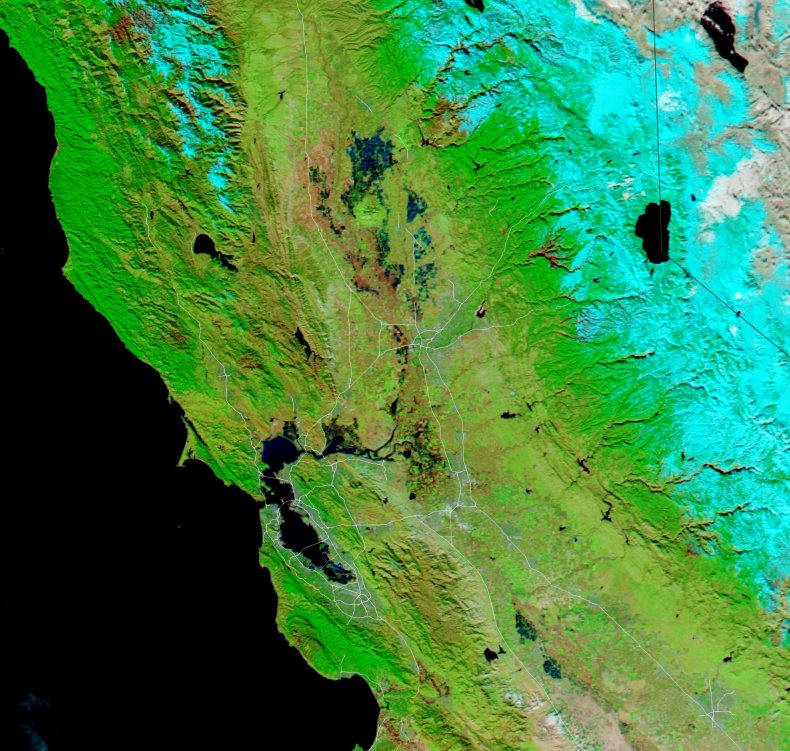
The massive impact of the torrential rains drenching California this week can be seen in dramatic images taken from space.
Pictures taken by NASA's Aqua satellite using the Moderate Resolution Imaging Spectroradiometer (MODIS) show the shocking difference in water coverage across northern California between December 16, 2022, and January 3, 2023.
The deluge began on December 31 across northern and central California. According to the Bay Area National Weather Service (NWS), 5.46 inches of rain fell in a single day in San Francisco, making December 31 the second-wettest day since records began in 1849. The wettest day on record occurred in November 1994, when 5.54 inches of rain fell in 24 hours.
Sacramento has also suffered from the storm, with several roads flooding and local rural communities being evacuated. One person tragically drowned after becoming trapped in a submerged car on Dillard Road, near to Highway 99.
Monitoring a very active scene on Dillard Rd near Hwy 99. Point of interest appears to be a submerged vehicle. Stay tuned to @GoodDaySac as we work to get you answers @CBSSacramento pic.twitter.com/oBFYjMsxKI
— Molly Riehl (@MollyRiehl) January 1, 2023
Sudden rain storms like this one cause such a degree of flooding for a number of reasons. Excessive rain can cause rivers to overflow, while strong winds at the coast can force water onto land as a storm surge, the NWS says.
Additionally, once the ground becomes saturated with rainwater, it cannot absorb any more, causing the extra rain to run along the ground in a flash flood. This is especially a risk in densely populated areas, as buildings and highways further prevent the absorption of water into the ground.
In the U.S., flooding results in more deaths each year than tornadoes, hurricanes or lightning, the NWS states.
This surge of bad weather is caused by something known as an atmospheric river, a long and narrow band of water vapor that forms over the ocean. These atmospheric rivers are being slung off by a bomb cyclone over the Pacific, which is an area of concentrated low pressure—a bomb cyclone was also responsible for the frigid temperatures that buffeted the Midwest just before Christmas.
Even more bad weather is headed toward the Bay Area and surrounds as the week continues, the NWS warned.
"A potent atmospheric river will begin to impact the region Wednesday and continue into Thursday. This will bring substantial rainfall to the San Francisco Bay Area and Central Coast on top of already saturated soils. As a result look for rapid rises in area creeks, streams, and rivers," the NWS said in a statement, issuing a flooding warning between January 4 and 5.
Another three inches of rain are expected to fall in urban San Francisco, with between 5 and 8 inches in the valleys and mountains nearby.
The incoming atmospheric river has been dubbed a "pineapple express" as it originated near Hawaii.
Here we go again, but this time with lots of wind.#PineappleExpress heading our way for midweek.
— NWS Bay Area 🌉 (@NWSBayArea) January 2, 2023
Checkout the plume of moisture peeling off the tropics, just NW of the Hawaiian Islands.
Monday/Tuesday are prep days.#cawx pic.twitter.com/F7Q6qbF5K8
"We have significant concerns, we're particularly concerned about later Wednesday, and into Thursday morning. Anyone living near streams, creeks and rivers should be prepared to get out," Eric Kurth, a meteorologist at the National Weather Service's Sacramento office, told SFGATE on January 3.
Do you have a tip on a science story that Newsweek should be covering? Do you have a question about flooding? Let us know via science@newsweek.com.
Uncommon Knowledge
Newsweek is committed to challenging conventional wisdom and finding connections in the search for common ground.
Newsweek is committed to challenging conventional wisdom and finding connections in the search for common ground.
About the writer
Jess Thomson is a Newsweek Science Reporter based in London UK. Her focus is reporting on science, technology and healthcare. ... Read more
To read how Newsweek uses AI as a newsroom tool, Click here.